Nadhir
MOHAMED MEHDI BOURAHLA

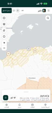
Nadhir is an independent app. It does not represent any government entity. Nadhir brings Algeria's hazards onto one map and alerts you about your commune. What Nadhir shows: • Wildfires: satellite detections and Civil Protection bulletins. • Weather: warnings from the national weather office (ONM) and fire danger. • Roads: closures and traffic information. • Earthquakes and other hazards. Alerts: • Pick one or more communes to get their alerts, no account needed. • Turn on "Also follow where I am" and the phone works out its commune and subscribes to its alerts. Following never sends your exact position. • With an account, create watch zones around your home or work. Survival mode: • Pre-approved guidance that works offline, emergency numbers (14, 1070, 112), and a message to reassure your family. Citizen reports: • Report a fire or a closed road. A report is published after it is checked, without your name or photo. Official sources: • Weather warnings: Office National de la Météorologie (ONM) – https://www.meteo.dz • Fire and emergency bulletins: Protection Civile (DGPC), official channel – https://t.me/DGPCDZ • Satellite fire detections: NASA FIRMS – https://www.earthdata.nasa.gov/data/tools/firms • Fire danger: Copernicus EFFIS – https://forest-fire.emergency.copernicus.eu • Lightning and satellite data: EUMETSAT – https://www.eumetsat.int • Earthquakes: EMSC – https://www.emsc-csem.org Each item in the app links to or names its source. Nadhir is not affiliated with these organisations. In danger, call Civil Protection on 14.
Screenshots