NYC Subway Map & Metro Guide
Alisher Fayzullaev

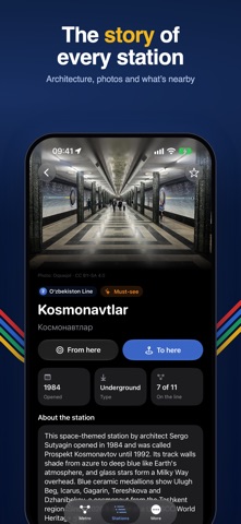
NYC Subway Map & Metro Guide puts the New York subway map and the metro maps of 8 more cities in one app: London, Paris, Rome, Berlin, Madrid, Barcelona, Milan and Tashkent. The subway map and routes work offline, so you can plan a trip on the New York subway even underground. • Metro map of every city. A clear, zoomable map of all lines and stations — all 25 New York subway services and 446 stations, the London Underground, the Paris Métro, the Berlin U-Bahn and the metros of Madrid, Barcelona, Milan, Rome and Tashkent. The metro map works without the internet. • Route planner. Choose "From" and "To" and get the fastest route with transfers, stops and travel time — offline, too. In Berlin the times come from the timetable, and the station screen shows the next trains in real time. • Beautiful stations and sights. Photos and stories of the most beautiful stations, and sights near the metro, each with its nearest station. In 3D you can fly around a landmark. • City map. All stations on the city map, your location and the nearest station with walking time. • Pick a city with one tap, or let the app pick the city you are in. • Favourites, light and dark theme. No ads, no sign-up. App language: English, Russian, Uzbek, German, French, Spanish, Italian. Travel times outside Berlin are estimates based on the distance between stations. This is an unofficial app, not affiliated with MTA, TfL, BVG, RATP, Metro de Madrid, TMB, ATM, ATAC or Toshkent Metropoliteni.
Screenshots