Offline Topo Map
Florian Zindel

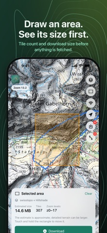
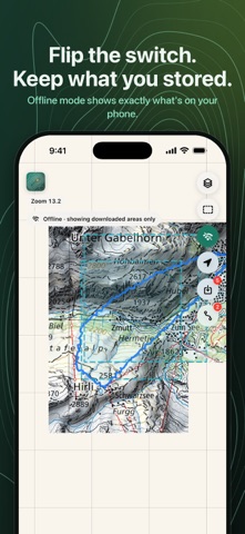
No account. No subscription. No tracking. Official maps across borders. Offline Topo Map puts the national topo maps of Switzerland, France, Germany, Austria and South Tyrol on your iPhone and iPad, with OpenTopoMap and TopPlusOpen for the rest of Europe. Draw a rectangle over the area you are heading into, download it, and the map keeps working where the signal doesn't, with no connection at all. WHAT YOU GET • Six topo maps, one tap apart — OpenTopoMap (worldwide), swisstopo (Switzerland), Plan IGN (France), TopPlusOpen (Germany and Europe), basemap.at (Austria) and South Tyrol. • Coordinates and a rescue card — touch and hold any point, or tap your own position, to see its coordinates (decimal degrees, DMS, degrees and decimal minutes, UTM, and Swiss LV95 inside Switzerland), its altitude and the local emergency numbers: 1414 Rega in Switzerland and Liechtenstein, 140 Alpine emergency in Austria, 112 everywhere. Copy or share them in one tap, or open a high-contrast rescue card to read out to a dispatcher, with call buttons. Works offline. • Winter layers for Switzerland — slopes over 30°, ski touring routes, snowshoe routes and wildlife quiet zones from swisstopo, downloadable for offline use like any overlay. • Slopes for France — steepness above 30° from IGN, across the French mountains. • Hillshade on any map — shaded relief drawn on your phone from open elevation data. • Scale bar and compass — read distances, see your heading, or lock rotation to keep north up. • Draw it, download it — drag a rectangle and download zoom levels 0 to 17 with the overlays you have switched on. Tile count and estimated size are shown first. • Your GPX tracks, from any app — share a .gpx file from Files, Mail or Safari and it appears on the map. Rename, hide or remove tracks. • The offline switch — the map shows only what you have stored, with every saved area outlined. • Downloads that finish — lock the phone or lose the connection and nothing is lost; one tap fetches the rest. • Your storage, your rules — a downloads list shows each area with its map, size and date. • In your language — English, German, French, Italian, Spanish, Dutch and Czech. BUILT FOR THE OUTDOORS Plan at home, then find your way on a hut-to-hut trek, a ski tour in the Dolomites or a bikepacking trip through valleys with one bar of signal or none. No roaming data needed abroad. The app requests map tiles and nothing else: no ads, no analytics, no personal data collected. Your location and GPX files stay on your device. BUILT ON OPEN DATA OpenTopoMap © OpenTopoMap (CC-BY-SA), map data © OpenStreetMap contributors, SRTM. swisstopo maps and winter layers © swisstopo; wildlife quiet zones © BAFU. Plan IGN and slopes © IGN, Licence Ouverte Etalab 2.0. TopPlusOpen © BKG, dl-de/by-2-0. basemap.at, CC BY 4.0. South Tyrol © Autonome Provinz Bozen – Südtirol, CC0. Relief from AWS Terrain Tiles, EU-DEM © Copernicus, SRTM/USGS. Offline Topo Map is an independent client and is not affiliated with any of these providers. Each download is capped at 15,000 tiles, and the app backs off whenever a server asks it to. A NOTE ON SAFETY Map data can be incomplete or outdated. Use the map alongside an official paper map and your own judgement, never as your only means of navigation in terrain where getting lost is dangerous. Questions or ideas? Visit offlinetopomap.com.
Screenshots