Rhumb: Sea Charts & Navigation
Yes Please Boats Ltd

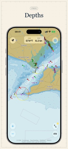
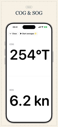
Open Rhumb and the whole world is already on the chart. Most sea-chart apps sell the chart one region at a time, so planning a long passage means buying pack after pack. In Rhumb the chart covers every ocean, included and free, and your position, course, and speed are live on the screen with no account required. You can plan a passage across the Atlantic without paying for the water it crosses. Because Rhumb carries nothing extra, it costs a fraction of what the professional apps charge, and when you are ready to plan, Rhumb Premium draws a route that avoids land. Rhumb is built by a Yachtmaster Offshore skipper who uses it on his own passages. It is made for people learning to navigate — RYA Day Skipper level and below — for skippers who forget the details between seasons, and for anyone in a dinghy, RIB, kayak, or on a paddleboard who wants a clear view of the seamarks around them. Crew on someone else's boat get their own view of position, course, and speed from the free tier. THE CHART • The whole world's chart included — buoys, beacons, lights, and harbour marks from OpenSeaMap on a clean base map • North-up, always — the chart never rotates; your boat and your course do • Day, twilight, and night appearances that switch automatically with the sun at your position • Your position, course over ground (COG), and speed over ground (SOG), live on the chart • Depths: shading in bands down to 20 m, contour lines, and soundings, worldwide and free. They come from the EMODnet and GEBCO seabed grids. Use them to see the shape of the seabed, and check them against an official chart • Rhumb needs a data connection for the chart today; offline charts are in development NAVIGATE • Dividers: rhumb-line distance and bearing between any two points, in nautical miles and °T • Full-screen instruments: COG and SOG, readable at arm's length at the helm • Markers: name and categorise anchorages, hazards, and marinas — stored in your own private iCloud, where only you can read them RHUMB PREMIUM • Auto-routing: tap waypoints and get a route that avoids land, with distance for every leg • Average SOG over the last minute, ten minutes, and hour — live on the instruments, kept complete in the background. Watch the tide help or hurt on passage. • £19.99 a year or £3.99 a month, with a one-week free trial. The chart and navigation essentials stay free, and you can cancel in your Apple Account settings at any time. The subscription renews automatically unless cancelled at least 24 hours before the end of the current period. Payment is charged to your Apple Account. IMPORTANT Rhumb is an aid for recreational planning. It does not replace official charts, official publications, or safe navigation practice. Routes avoid land. They do not check depth, so always verify depths against your chart. Depths come from the EMODnet and GEBCO seabed grids and are not surveyed chart data. Outside Europe most depths come from GEBCO, which uses mean sea level, so at low tide the water can be shallower than Rhumb shows. Terms of Use: https://rhumbapp.com/terms Privacy Policy: https://rhumbapp.com/privacy
Screenshots