Nakasendo Route Map Navigator
Takuya Takahashi

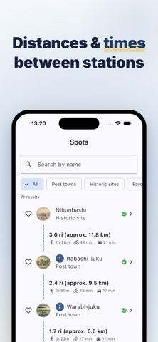
Nakasendo Route Map Navigator is a route-guidance app for walking the Nakasendo, one of the two great highways of Edo-era Japan. Follow the route on the map, see where you are, and move from one post town to the next without getting lost. ▶ Navigate the route on the map The full Nakasendo route and all 69 post towns are plotted on the map, so you always know where you are and which way to go. Check the distance and the walking, cycling or driving time to the next station, and plan your day on the trail. ▶ Distances & times to each station See the distance between stations together with walking, cycling and driving times, so you can keep a comfortable pace. ▶ In-depth post-town notes (handy extras) Every town comes with notes on its history and highlights. Tap any place name to look it up on Google or ask an AI for more context as you walk. ▶ A Hiroshige ukiyo-e collection View the woodblock prints tied to each station in high resolution. Complete a town to earn a commemorative stamp, filling in your ukiyo-e board as you travel. ▶ Audio guide while you walk Listen to the commentary read aloud, with adjustable voice and speed, so you can keep your eyes on the map and the scenery. ▶ Great for ・ Walking and completing the Nakasendo with route guidance ・ Post-town visits, highway walks, hiking and walking ・ Anyone who also enjoys history and ukiyo-e along the way ・ Travelers who dream of walking the Tokaido too Grab the map and follow the old Nakasendo highway.
Screenshots