Acrea: GPS Land Area Measure
Benthotage Udayashan

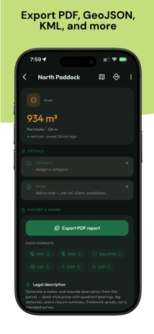
Measure any plot of land in seconds. Acrea turns your phone into a precise GPS area, distance, and perimeter measuring tool - perfect for farmers, surveyors, real-estate agents, roofers, and anyone who needs accurate land measurements on the go. Walk the boundary with live GPS or tap points on a satellite map, and Acrea instantly calculates the area and perimeter in the units you choose. No paper, no guesswork, no expensive equipment. WHAT YOU CAN DO • Measure area and distance by tapping points on a high-resolution satellite map • Get instant results in acres, hectares, square meters, square feet, and more • Drop, drag, and fine-tune markers for exact boundaries • Import your existing parcels - free - from KML, KMZ, GeoJSON, CSV, DXF or Shapefile • Tap a saved parcel on the map to select and edit it; duplicate any measurement in a tap • Save, name, and colour-code your measurements into categories and groups • Get directions to any saved site • Export a clean PDF report with a satellite snapshot - great for clients & records PERFECT FOR • Farmers & agriculture - field size, crop planning, fencing • Land surveying & real estate - plot and property boundaries • Roofers & contractors - roof area and material estimates • Landscapers & gardeners - lawns, gardens, paving • Construction & fencing - site layout and quantity takeoffs ACREA PRO Upgrade to Acrea Pro for survey-grade tools: • Subdivide - carve a parcel into a grid of equal lots by count or size, rotated to any angle • Split - divide an area in two with a clean cut, or solve for a target lot size ("carve a 1-acre lot") • Merge & Trim - fuse adjacent parcels into one, or subtract one parcel from another • Move - drag a whole measurement, or offset it by an exact bearing & distance • Walk-to-measure - record a boundary by walking it, area updates live • COGO traverse entry - enter boundaries by bearing & distance with a closure check • Legal descriptions - generate metes-and-bounds, deed-style text for any parcel • Precise coordinate entry - type exact latitude/longitude for any corner • Cut-out areas - subtract ponds, buildings or any inner region from the total • On-map digital compass - read a live magnetic bearing while you measure • Interior angle readouts at every corner of a parcel • Professional exports - PDF, CAD (DXF), GIS Shapefile, KML, KMZ, GeoJSON & CSV • Bulk export - many measurements, or all of them, in a single file • Offline maps - download tiles and measure anywhere, even with no signal • Premium map styles • Unlimited saved measurements Acrea is built to be fast, accurate, and effortless - whether you're standing in a field or planning from your desk. Download Acrea and measure your land the smart way. Terms of Use (EULA): https://acrea-web.vercel.app/terms
Screenshots