GPX Viewer PRO
mustafa pistofoglu

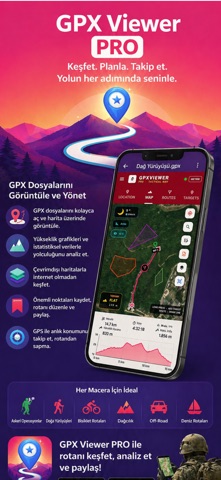
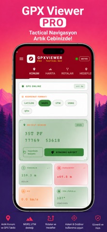
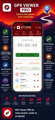
GPX Viewer PRO — Professional GPS Navigation and Field Management App A comprehensive navigation solution for field personnel, hikers, hunters, nature photographers, off-road enthusiasts, and all professionals working with GPS data. Used worldwide with 22 language support. ▶ MULTI-FORMAT FILE SUPPORT - GPX (waypoint, route, track) — full support - KML (Google Earth) — Point, LineString, Polygon, MultiGeometry - KMZ (compressed KML) — automatic extraction - GeoJSON — for modern web maps - gx:Track — Garmin watches and devices - MBTiles — custom offline map format - CSV and MGRS coordinate list import - One-tap file open from WhatsApp, Mail, Files ▶ TACTICAL COORDINATE SYSTEMS - MGRS (Military Grid Reference System) — military standard - UTM, USNG, and decimal LAT/LON formats - Real-time coordinate conversion - DTG (Date-Time Group) time format ▶ ADVANCED MAP SYSTEM - Topographic, satellite, road, and hybrid map layers - Military grid line (MGRS grid overlay) - Offline map download — operate without cellular network - MBTiles format custom map loading - Elevation profile and slope analysis ▶ TARGET & WAYPOINT MANAGEMENT - Unlimited waypoint saving and management - Manual target entry with MGRS coordinates - Long-press map to set quick targets - Real-time distance, bearing, and ETA to active target - Auto map compass lock when target selected - Waypoint sharing via custom deep link ▶ ADVANCED ROUTE SYSTEM - Draw routes on map - Multi-point itinerary planning - Full route editing — move, delete, add points - Segment intermediate point editing - Route deviation alerts - Navigation mode — active routing - Export routes as GPX/KML ▶ FIELD TRACK LOGGING - Continuous background tracking - Pause / resume - Speed, distance, elevation, climb statistics - Max and average speed tracking - Track Navigation — use saved tracks as routes - Smart simplification — auto-optimization for long tracks - Track sharing (GPX/KML format) ▶ TACTICAL COMPASS - Precise digital compass - Target bearing and relative direction - Route deviation indicator - Full-screen radar scan compass mode ▶ MODERN LOCATION SCREEN - Tactical HUD interface - Pulsing GPS signal animation - Sensor bars and real-time indicators - One-tap coordinate copy - Modernized barometer panel ▶ AREA MANAGEMENT - Create areas with polygons - Auto area import from KML (cadastral compatible) - Area calculation (m² / km² / acres / hectares) - Multiple area saving ▶ FIELD TOOLS - Coordinate converter (LAT/LON ↔ MGRS ↔ UTM) - Distance measurement tool - Offline map cache management - Weather integration ▶ 22 LANGUAGE SUPPORT Turkish, English, German, French, Spanish, Italian, Portuguese, Russian, Chinese, Japanese, Korean, Arabic, Ukrainian, Norwegian, Bulgarian, Croatian, Lithuanian, Romanian, Slovak, Slovenian, Indonesian, Persian ▶ DARK / LIGHT THEME - Dark theme — night and low-light use - Light theme — daytime field use ▶ COMPLETE PRIVACY - All data stays on your device - No server uploads - No third-party sharing - No ads — completely clean interface Stay one step ahead in the field with GPX Viewer PRO. Know your coordinates. Plan your route. Reach your goal.
Screenshots