Skyty: Offline Flight Tracker
Kim Engels

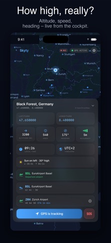
Your flight. Your data. No WiFi needed. Skyty turns your iPhone into a personal flight instrument. Live GPS position, altitude above ground (AGL), speed, heading, and a beautiful offline map — all in airplane mode. WHY PASSENGERS & PILOTS LOVE SKYTY • 100% offline. GPS works without WiFi or cellular. • 47,000+ airports worldwide (IATA + ICAO) • True altitude above ground using NASA terrain data • One-time purchase. No tracking. No ads. No accounts. BUILT FOR THE WINDOW SEAT Ever wondered "what am I flying over?" Skyty tells you — in real time, without paying for in-flight WiFi. Cities, mountains, coastlines, and the nearest airport, always on screen. PRECISE FLIGHT DATA • Live position, speed, heading and GPS accuracy • Altitude in GPS (WGS84) or MSL (mean sea level) • Altitude above ground (AGL) powered by SRTM terrain • Next airport with distance and bearing • Destination airport with ETA FOR PILOTS & GLIDER PILOTS • Flight recording with distance, duration, max altitude, avg speed • GPX export to your favorite flight log • Runway prediction — active runway highlighted on map • HD terrain data (~900m grid) for precise AGL • Not certified avionics — optimized as a passenger companion with pilot features APPLE WATCH & WIDGETS • Companion app for Apple Watch • Home Screen widgets for live position • Live Activity during flight 4 MAP THEMES Aviation Dark (cockpit-optimized), Aviation Light, Satellite, Topographic. PRIVACY FIRST Skyty processes GPS data exclusively on your device. No cloud. No tracking. No analytics. No accounts. Your flight history stays local. FREE • Live position & speed • GPS altitude • Basic offline map PREMIUM — ONE-TIME PURCHASE • Everything in Free • Altitude above ground (AGL) • HD terrain data • Flight recording & GPX export • Altitude profile chart • HD world map (Zoom 0–10) • All map themes • Sun position indicator with seat recommendation No subscription. No renewal. Works fully offline. DATA SOURCES OpenStreetMap (ODbL) · Protomaps (BSD/CC0) · MapLibre Native (BSD-3) · OurAirports (Public Domain) · NASA SRTM (Public Domain) · Natural Earth (Public Domain) Made with GPS data and window seats in Zürich.
Screenshots