Geo XY Pointer - GPS Grid
QAEE CONPUUTENG

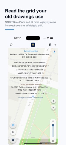
Holding a 1927-era plat, a deed description, or an old agency drawing? Those coordinates are NAD27 State Plane, not what your phone reports - and the difference on the ground is tens of metres. This app shows both at once. SPCS83 and UTM on top, NAD27 State Plane in US survey feet and NAD27 UTM right underneath, updating live as you walk. The conversion uses NADCON, the National Geodetic Survey's own grid, so the number matches the drawing rather than approximating it. Try all features completely free for the first month. [ Key Features ] - Real-Time Coordinate Display: Simultaneously shows Latitude/Longitude (WGS84), UTM, and MGRS. - Legacy Grids: NAD27 State Plane and NAD27 UTM via NADCON, for checking older plats, deeds and boundary work. - Enter a Coordinate, Go There: Type or paste a grid coordinate and the map jumps to it. - Multiple Points at Once: Paste a list of coordinates, drop them together, and step through them one by one. - Feet or Metres: Switch between metres, US survey feet and international feet - every readout and every entry follows. - Distance and Bearing: Range and direction from where you stand to the pin, with live GPS accuracy. - CSV Export: Send saved points out as CSV for your office software. - Street View: Jump from any point straight to Google Street View. - Pin Function: Tap the map to drop a pin and read its coordinates and address. - Favorites Manager: Manage multiple job sites and reference points efficiently. - Address Lookup: Shows the street address of your location or any pin. - Auto-Detect Local Coordinate Systems: Automatically identifies and displays the correct local grid and zone worldwide. - One-Tap Copy: Copy retrieved coordinate data to your clipboard with a single tap. - Share & Report: Capture screenshots containing coordinate data to easily share or save via email and messaging apps. - Transparent Map Overlay: Seamlessly layer satellite imagery with OSM (OpenStreetMap) to read terrain, vegetation, roads, and facilities at once. Ideal for construction, civil engineering, environmental surveys, forestry, mountain rescue, and any scenario demanding precise location data. [ Supported Local Coordinate Systems — 40+ countries worldwide ] Asia & Oceania: Japan (JPRC Zones 1-19), South Korea (Korean 2000), China (CGCS2000), Taiwan (TWD97), Hong Kong (HK1980), Malaysia (GDM2000), Singapore (SVY21), Indonesia, Vietnam, Thailand, Philippines, Bangladesh, Pakistan, Australia (GDA2020/MGA2020), New Zealand (NZTM2000). Europe: United Kingdom (British National Grid), Ireland (ITM), France (Lambert-93), Germany (ETRS89/UTM), Netherlands (RD New), Switzerland (LV95), Belgium (Lambert 2008), Luxembourg (LUREF), Italy (Gauss-Boaga), Portugal (TM06), Greece (Greek Grid), Poland (PUWG 2000), Czechia & Slovakia (S-JTSK / Křovák), Hungary (EOV), Romania (Stereo 70), the Nordics (Denmark, Sweden, Finland, Norway, Iceland), the Baltics (Estonia, Latvia, Lithuania), Russia, Turkey. Middle East, Africa & South America: Israel (ITM), Egypt, Qatar (QND95), South Africa, Nigeria, Argentina (POSGAR 2007). North America: United States — all 50 states (NAD83 State Plane Coordinate System / SPCS83), e.g. California, Texas, New York, Florida, Alaska, Hawaii; Puerto Rico. [ Legacy Grids on Board - converted with each country's official grid shift ] NAD27 State Plane - NAD27 UTM - OSGB36 - DHDN / Gauss-Kruger - NTF / Lambert - CH1903 / LV03 - MGI / Austria GK - Belge 1972 / Lambert 72 - Amersfoort / RD New - ED50 - Datum 73 - HD72 / EOV - S-JTSK / Krovak - ISN93 - LKS-92 - AGD66 / AMG - NZGD49 / NZMG - SAD69 - Tokyo Datum - System 34 / System 45 (DK) Canada (NAD83 MTM) - India (Survey of India zones) - everywhere else: UTM / MGRS worldwide. Note: current grids are projected from WGS84 without a datum shift (up to ~1–2 m); not for survey work. Terms of Use: https://www.apple.com/legal/internet-services/itunes/dev/stdeula/ Privacy Policy: https://qconp.com/privacy
Screenshots