Neshan| Map & Navigation App
نقشه و مسیریاب نشان

4.5 stars246,363 reviews10,000,000+Free
Maps & NavigationEveryoneVersion 14.8.10Updated 2/17/2026, 12:22:05 PM
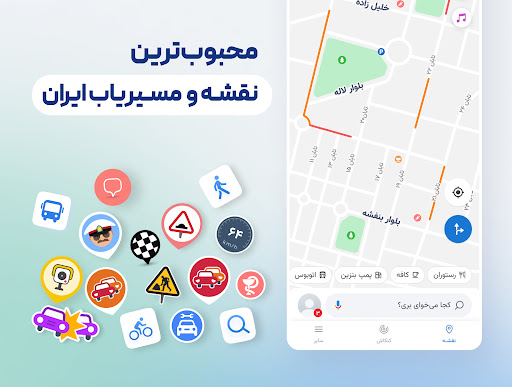
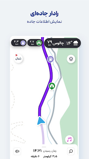
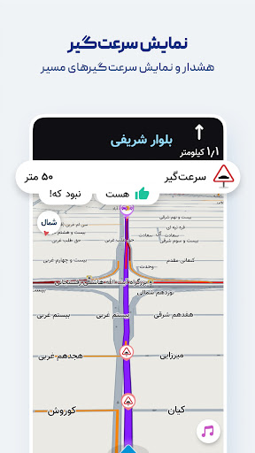
Open in StoreUsing GPS and real-time traffic data—just like leading international navigation apps—Neshan suggests the fastest, least congested routes, and alerts you along the way when you are approaching speed cameras or police checkpoints.
Features like displaying air pollution levels in cities with monitoring stations, warning about speed bumps, routing with traffic restriction and low-emission zone considerations, combined bus-and-metro navigation, motorcycle routing, and more have made Neshan the go-to choice for many Iranian users, including ride-hailing drivers on Snapp and Tapsi, offering unique advantages over other mapping and navigation services.
Key features and benefits of Neshan:
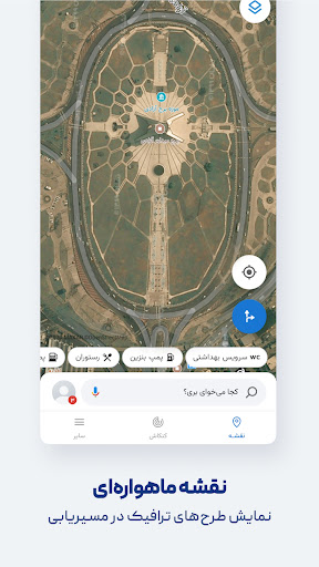
Maps of all cities and countries worldwide, powered by open and free OpenStreetMap data
Display of air pollution monitoring stations in all cities that have them
Detailed offline maps of all cities with live traffic information
Ability to choose the best and cheapest way to reach your destination with combined bus and metro routing
Global maps with navigation to any desired location
Persian voice guidance that speaks street names so you don’t need to look at the map
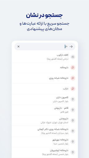
Find nearby public places such as restaurants, gas stations, ATMs, hotels, and more
Search without typing (Persian speech recognition)
Routing that accounts for traffic restriction zones and low-emission zones, helping you avoid entering them unintentionally
Option to select direct routes in Neshan’s navigation settings
Alerts for police presence, speed cameras, speed bumps, and traffic
Accurate location detection using GPS
With Neshan maps and navigation, you’ll know your way anywhere.
Contact Neshan:
Email: support@neshan.org
Telegram Support: @neshan_admin
Instagram: instagram.com/neshan_nav
Features like displaying air pollution levels in cities with monitoring stations, warning about speed bumps, routing with traffic restriction and low-emission zone considerations, combined bus-and-metro navigation, motorcycle routing, and more have made Neshan the go-to choice for many Iranian users, including ride-hailing drivers on Snapp and Tapsi, offering unique advantages over other mapping and navigation services.
Key features and benefits of Neshan:
Maps of all cities and countries worldwide, powered by open and free OpenStreetMap data
Display of air pollution monitoring stations in all cities that have them
Detailed offline maps of all cities with live traffic information
Ability to choose the best and cheapest way to reach your destination with combined bus and metro routing
Global maps with navigation to any desired location
Persian voice guidance that speaks street names so you don’t need to look at the map
Find nearby public places such as restaurants, gas stations, ATMs, hotels, and more
Search without typing (Persian speech recognition)
Routing that accounts for traffic restriction zones and low-emission zones, helping you avoid entering them unintentionally
Option to select direct routes in Neshan’s navigation settings
Alerts for police presence, speed cameras, speed bumps, and traffic
Accurate location detection using GPS
With Neshan maps and navigation, you’ll know your way anywhere.
Contact Neshan:
Email: support@neshan.org
Telegram Support: @neshan_admin
Instagram: instagram.com/neshan_nav
Developer email
support@neshan.org
Developer website
http://neshan.orgReleased
Mar 19, 2017
Current version
14.8.10
Android version
5.0
Reviews & Ratings
4.5
out of 5
5
4
3
2
1
😊 Highly rated by users
246,363 reviewsScreenshots