Sjøkart
Bullfolio.no

Sjøkart is a modern chartplotter for recreational boaters in Norwegian waters with, among other things, official nautical charts, route plotting, real-time AIS, anchor watch and depth warning adapted to your boat, depth warning adapted to your boat, smart route planning and offline maps that work without mobile coverage. The app has no binding subscription, is completely ad-free and does not store any information about you or your usage.
OFFICIAL NORWEGIAN NATURAL CHARTS
Detailed nautical charts from the Norwegian Mapping Authority with depth contours, beacons and lighthouses, the same maps that the pros use. OpenSeaMap overlay shows buoys and port information.
SEE VESSELS AROUND YOU
Turn on the AIS layer and see other commercial vessels in real time right on the map. Tap on a vessel to see name, speed and course, and get a better overview in busy waters and approaches.
ANCHOR WATCH
Stay safe at anchor. Set a custom sway radius around your anchorage, and the app will alert you with a clear alarm if your boat drifts outside. Monitoring continues in the background even when the screen is off.
DEPTH WARNING CUSTOMIZED FOR YOUR BOAT
Enter your boat's draft, height and desired safety margin. The app retrieves depth data and height information on bridges and other obstacles, and calculates clearance where available.
ROUTE PLANNING
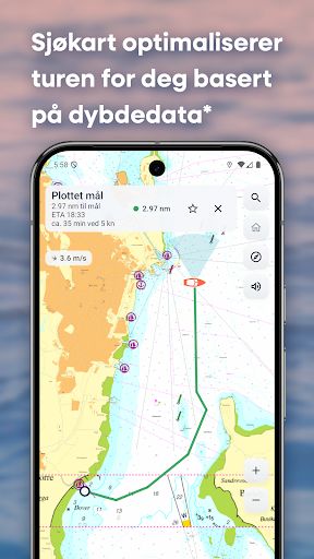
Plot waypoints directly on the map, or let the app calculate the best route automatically. A depth-aware search avoids land and shoals. The route line is colored green, orange or red, so you see risky sections before you get there. The route status indicator shows whether you are on route, drifting or off course.
WEATHER FORECAST WITH WAVE HEIGHT
Weather forecast from MET Norway right in the app, including wave height and tide times, so you can plan your trip according to the conditions.
OFFLINE MAPS FOR THE WHOLE OF NORWAY
Download maps in advance and navigate safely even without mobile coverage. 11 coastal regions cover the entire Norwegian coast from the Oslofjord to East Finnmark, and over 30 custom regions cover lakes, waters and rivers inland, such as Mjøsa, Tyrifjorden, Randsfjorden and Femunden.
OWN POINTS ON THE MAP
Save favorite places such as natural harbors, fishing spots and docks, with your own icon, note and picture. Share your points with other Sjøkart users.
TRACK LOG AND TRIP DIARY
The app automatically logs your trips in the background and continues even if the app is closed. See distance, duration and maximum speed per trip. Export or import trips for backup, sharing or recovery. Everything is stored locally on the device.
CHECKLIST AND SYMBOLS GUIDE
Sjøkart has practical checklists and a guide with illustrations and explanations of map symbols, things you can see at sea, and what you should do in various emergency situations.
MORE IN THE APP
- Search all Norwegian place names via the Norwegian Mapping Authority
- Favorites and home port for one-touch navigation
- Prediction line for 1, 3, 5, 10, 30 and 60 minutes
- Live wind direction, fixed in relation to north or relative to the device
- Dark theme that reduces glare during night navigation
- Optimized for mobile and tablet, portrait and landscape
- No account or registration, everything is stored locally on the device
- No advertising, no tracking of users
NB! Sjøkart is a navigation aid and does not replace official nautical charts or approved navigation equipment. The user is responsible for safe navigation.
OFFICIAL NORWEGIAN NATURAL CHARTS
Detailed nautical charts from the Norwegian Mapping Authority with depth contours, beacons and lighthouses, the same maps that the pros use. OpenSeaMap overlay shows buoys and port information.
SEE VESSELS AROUND YOU
Turn on the AIS layer and see other commercial vessels in real time right on the map. Tap on a vessel to see name, speed and course, and get a better overview in busy waters and approaches.
ANCHOR WATCH
Stay safe at anchor. Set a custom sway radius around your anchorage, and the app will alert you with a clear alarm if your boat drifts outside. Monitoring continues in the background even when the screen is off.
DEPTH WARNING CUSTOMIZED FOR YOUR BOAT
Enter your boat's draft, height and desired safety margin. The app retrieves depth data and height information on bridges and other obstacles, and calculates clearance where available.
ROUTE PLANNING
Plot waypoints directly on the map, or let the app calculate the best route automatically. A depth-aware search avoids land and shoals. The route line is colored green, orange or red, so you see risky sections before you get there. The route status indicator shows whether you are on route, drifting or off course.
WEATHER FORECAST WITH WAVE HEIGHT
Weather forecast from MET Norway right in the app, including wave height and tide times, so you can plan your trip according to the conditions.
OFFLINE MAPS FOR THE WHOLE OF NORWAY
Download maps in advance and navigate safely even without mobile coverage. 11 coastal regions cover the entire Norwegian coast from the Oslofjord to East Finnmark, and over 30 custom regions cover lakes, waters and rivers inland, such as Mjøsa, Tyrifjorden, Randsfjorden and Femunden.
OWN POINTS ON THE MAP
Save favorite places such as natural harbors, fishing spots and docks, with your own icon, note and picture. Share your points with other Sjøkart users.
TRACK LOG AND TRIP DIARY
The app automatically logs your trips in the background and continues even if the app is closed. See distance, duration and maximum speed per trip. Export or import trips for backup, sharing or recovery. Everything is stored locally on the device.
CHECKLIST AND SYMBOLS GUIDE
Sjøkart has practical checklists and a guide with illustrations and explanations of map symbols, things you can see at sea, and what you should do in various emergency situations.
MORE IN THE APP
- Search all Norwegian place names via the Norwegian Mapping Authority
- Favorites and home port for one-touch navigation
- Prediction line for 1, 3, 5, 10, 30 and 60 minutes
- Live wind direction, fixed in relation to north or relative to the device
- Dark theme that reduces glare during night navigation
- Optimized for mobile and tablet, portrait and landscape
- No account or registration, everything is stored locally on the device
- No advertising, no tracking of users
NB! Sjøkart is a navigation aid and does not replace official nautical charts or approved navigation equipment. The user is responsible for safe navigation.
Developer email
post@bullfolio.no
Developer website
https://sjokart.bullfolio.no/Current version
1.2.5
Android version
8.0
Screenshots