Flight Map Pro
Makro Productions

Flight Map Pro is your personal on-board flight companion for Android. Whether you're a passenger curious about your position or a pilot looking for a heads-up display, Flight Map Pro works entirely offline — no internet required, fully compatible with Airplane Mode.
Cockpit View
A realistic artificial horizon instrument shows your pitch, roll and bank angle in real time. Switch to terrain mode to see a live perspective view of the ground ahead — the terrain scrolls as you fly, zooms with a pinch gesture, and remembers your zoom level between sessions. A built-in distance scale shows you exactly how far ahead you can see.
Navigation
- Real-time aircraft position on a zoomable offline world map
- Line to destination on both the map and cockpit terrain view
- Search from a database of world airports or enter any longitude/latitude coordinates (decimal or degrees/minutes/seconds)
- Estimated Time to Destination and Time of Arrival based on aircraft type and current speed
- Route recording — automatically starts when speed exceeds 180 km/h, saved with date and destination
Satellite View
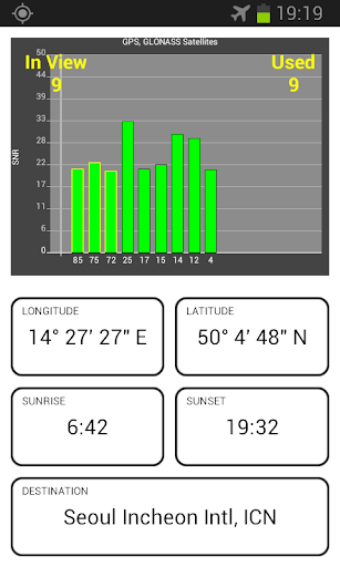
A live chart shows all visible GPS satellites, their signal strength and which ones are being used for the fix. Use it to find the best window seat for GPS reception.
Customisation
- Dark and Light skin
- Metric or Imperial units (km/mi, metres/feet)
- Terrain view on/off
- Multiple aircraft types for accurate ETA calculation
- Multi language
No internet required — the full world map is bundled in the app. Works even in Airplane Mode from the moment you take off.
Note: GPS performance depends on your device. For best results, place the phone near a window and allow it to acquire satellites before takeoff. A-GPS devices benefit from a brief internet connection on the ground before the flight. Does not work in Boeing 787 due to windows being tinted, rather than shutters, effectively blocking GPS signal inside the aircraft.
Cockpit View
A realistic artificial horizon instrument shows your pitch, roll and bank angle in real time. Switch to terrain mode to see a live perspective view of the ground ahead — the terrain scrolls as you fly, zooms with a pinch gesture, and remembers your zoom level between sessions. A built-in distance scale shows you exactly how far ahead you can see.
Navigation
- Real-time aircraft position on a zoomable offline world map
- Line to destination on both the map and cockpit terrain view
- Search from a database of world airports or enter any longitude/latitude coordinates (decimal or degrees/minutes/seconds)
- Estimated Time to Destination and Time of Arrival based on aircraft type and current speed
- Route recording — automatically starts when speed exceeds 180 km/h, saved with date and destination
Satellite View
A live chart shows all visible GPS satellites, their signal strength and which ones are being used for the fix. Use it to find the best window seat for GPS reception.
Customisation
- Dark and Light skin
- Metric or Imperial units (km/mi, metres/feet)
- Terrain view on/off
- Multiple aircraft types for accurate ETA calculation
- Multi language
No internet required — the full world map is bundled in the app. Works even in Airplane Mode from the moment you take off.
Note: GPS performance depends on your device. For best results, place the phone near a window and allow it to acquire satellites before takeoff. A-GPS devices benefit from a brief internet connection on the ground before the flight. Does not work in Boeing 787 due to windows being tinted, rather than shutters, effectively blocking GPS signal inside the aircraft.
Developer email
makro.productions@haulis.com
Developer website
http://www.haulis.comReleased
Mar 21, 2026
Current version
1.4.2
Android version
5.0
Screenshots