Qendali Mining - DXF GeoPDF
Qendali

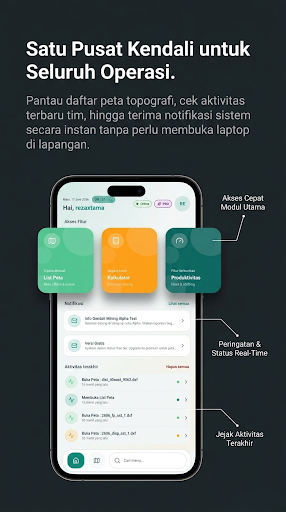
Qendali Mining is a native Android mobile app for open pit mine supervisors, surveyors, and mining engineers. Import DXF & GeoPDF files, offline maps, compass, clinometer, GPS camera, and cycle time calculator — all in one app.
Import DXF & GeoPDF files directly in the field. Visualize mine geometry, pit boundaries, and contours from DXF files without complex conversion. Open georeferenced GeoPDF maps for accurate navigation across the work area.
⛏️ KEY FEATURES
• MINING MAPS (MapLibre) — Satellite, terrain, and default basemaps. Multi-layer DXF overlays, GeoPDF layers, real-time GPS, track recording, save coordinate points + photos.
• DXF IMPORT — Open .dxf files (LWPOLYLINE, LINE, ARC, CIRCLE, TEXT, 3DFACE) as map layers instantly. ASCII DXF supported.
• GEOPDF IMPORT — Georeferenced maps (GPTS/LPTS) with on-demand tile rendering.
• DIGITAL COMPASS — Rotation vector sensor for bearing orientation in the field.
• CLINOMETER — Accelerometer sensor to measure pitch, roll, and slope/bench angles.
• GPS CAMERA — Photos with automatic geostamp: UTM/LatLng coordinates, UTM zone, address, mini-map, and compass. Tier-based watermark.
• CYCLE TIME CALCULATOR — Phase stopwatch (loading, hauling, queuing, dumping) for loaders & haulers, GPS distance & speed integration, history + cloud sync.
• DISTANCE & AREA MEASUREMENT — Measure distance with grade/slope, measure polygon area (native C++), snap to DXF layers.
• UTM / LATLNG / GEO COORDINATES — Coordinate bar, copy to clipboard, search & jump to UTM coordinates.
• AR INSPECTION (Pro) — Overlay DXF design onto the real world via ARCore.
• 3D MODE & GPS CALIBRATION (Pro) — Elevation and benchmark calibration + barometer.
• TEAMS COLLABORATION (Pro/Premium) — Post feed, comments, multi-party technical data sync.
• 19 LANGUAGES — Full localization: Indonesian, English, 中文, Português, Español, Русский, हिन्दी, Malay, ไทย, Tiếng Việt, Français, Deutsch, 日本語, 한국어, العربية, Türkçe, Монгол, Afrikaans, Filipino.
• PUSH NOTIFICATIONS — Real-time announcements & Teams activity updates.
• HOME SCREEN WIDGETS — Quick access to Maps, GPS Camera, Compass, Clinometer.
• OFFLINE-FIRST — DXF & GeoPDF files stored locally, works without signal in the pit area.
🎯 IDEAL FOR
• Mining Engineers & Geotechnical Engineers — Design vs. actual field validation.
• Mine Surveyors — DXF & GeoPDF spatial data access, distance/area measurement, GPS tracking.
• Supervisors & Operations Managers — Monitor loader/hauler cycle time from the pit front.
• Contractors & Consultants — Technical data sync via Teams.
🔒 SECURITY
Layered authentication, device activation, and technical data encryption to protect coordinates and strategic company information.
Keywords: DXF, GeoPDF, mining map, open pit, mining survey, mine surveyor, mining compass, clinometer, inclinometer, GPS camera, geostamp, cycle time mining, loader hauler, MapLibre, offline map, UTM coordinates, polygon, GPS tracking, AR inspection, coal mining, open pit mining.
Import DXF & GeoPDF files directly in the field. Visualize mine geometry, pit boundaries, and contours from DXF files without complex conversion. Open georeferenced GeoPDF maps for accurate navigation across the work area.
⛏️ KEY FEATURES
• MINING MAPS (MapLibre) — Satellite, terrain, and default basemaps. Multi-layer DXF overlays, GeoPDF layers, real-time GPS, track recording, save coordinate points + photos.
• DXF IMPORT — Open .dxf files (LWPOLYLINE, LINE, ARC, CIRCLE, TEXT, 3DFACE) as map layers instantly. ASCII DXF supported.
• GEOPDF IMPORT — Georeferenced maps (GPTS/LPTS) with on-demand tile rendering.
• DIGITAL COMPASS — Rotation vector sensor for bearing orientation in the field.
• CLINOMETER — Accelerometer sensor to measure pitch, roll, and slope/bench angles.
• GPS CAMERA — Photos with automatic geostamp: UTM/LatLng coordinates, UTM zone, address, mini-map, and compass. Tier-based watermark.
• CYCLE TIME CALCULATOR — Phase stopwatch (loading, hauling, queuing, dumping) for loaders & haulers, GPS distance & speed integration, history + cloud sync.
• DISTANCE & AREA MEASUREMENT — Measure distance with grade/slope, measure polygon area (native C++), snap to DXF layers.
• UTM / LATLNG / GEO COORDINATES — Coordinate bar, copy to clipboard, search & jump to UTM coordinates.
• AR INSPECTION (Pro) — Overlay DXF design onto the real world via ARCore.
• 3D MODE & GPS CALIBRATION (Pro) — Elevation and benchmark calibration + barometer.
• TEAMS COLLABORATION (Pro/Premium) — Post feed, comments, multi-party technical data sync.
• 19 LANGUAGES — Full localization: Indonesian, English, 中文, Português, Español, Русский, हिन्दी, Malay, ไทย, Tiếng Việt, Français, Deutsch, 日本語, 한국어, العربية, Türkçe, Монгол, Afrikaans, Filipino.
• PUSH NOTIFICATIONS — Real-time announcements & Teams activity updates.
• HOME SCREEN WIDGETS — Quick access to Maps, GPS Camera, Compass, Clinometer.
• OFFLINE-FIRST — DXF & GeoPDF files stored locally, works without signal in the pit area.
🎯 IDEAL FOR
• Mining Engineers & Geotechnical Engineers — Design vs. actual field validation.
• Mine Surveyors — DXF & GeoPDF spatial data access, distance/area measurement, GPS tracking.
• Supervisors & Operations Managers — Monitor loader/hauler cycle time from the pit front.
• Contractors & Consultants — Technical data sync via Teams.
🔒 SECURITY
Layered authentication, device activation, and technical data encryption to protect coordinates and strategic company information.
Keywords: DXF, GeoPDF, mining map, open pit, mining survey, mine surveyor, mining compass, clinometer, inclinometer, GPS camera, geostamp, cycle time mining, loader hauler, MapLibre, offline map, UTM coordinates, polygon, GPS tracking, AR inspection, coal mining, open pit mining.
Developer email
support@qendali.id
Developer website
https://qendali.idReleased
Jul 5, 2026
Current version
1.0.20
Android version
8.0
Screenshots