Skály ČR
Český horolezecký svaz

The Rocks of the Czech Republic application provides users with a complete database of all rock formations and climbing routes registered by the Czech Mountaineering Association, including clearly displayed information about current temporary and permanent climbing bans. With the Rocks of the Czech Republic application, you have up-to-date and verified information in real time in your pocket.
The Rocks of the Czech Republic application offers:
- a complete, up-to-date database of climbing rocks in the Czech Republic
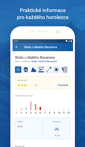
- basic parameters, description and characteristics of individual rocks and climbing routes
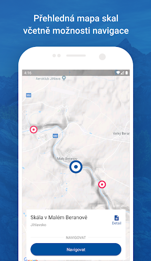
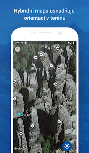
- marking the position of rocks on the map
- navigation for arriving at the rocks, including an azimuth direction indicator and distance
- rating the popularity of rocks and routes
- photo gallery of rocks and climbing routes with the option to add your own photos
- the option to measure and complete the missing position of the rock on the spot from the application
- the option to report damaged protection
- the option to complete the properties of rocks and routes
- marking of parking spaces and public transport stops near the rocks
- connection to navigation applications installed on the phone
- search results sorted by database structure and colored by object type
- offline mode with photos
- the option to update downloaded data for offline mode if there has been a change in the database
- search history
OFFLINE mode!
The application also works in offline mode. The necessary areas or sectors can be downloaded (including photos) to the phone for later use when you have a weak or no mobile signal. Even in offline mode, you can suggest changes to data, rate, add
location or add new photos. New data will be queued and transferred to the database only after the phone is connected to a signal.
By adding photos, coordinates and route characteristics, you will improve the quality of information that serves the entire climbing community.
Climbers for climbers. You can find detailed instructions for the application, tips, tricks and frequently asked questions on the support page.
The development of the application continues. Other advanced features and improvements are in preparation!
What’s New in This Version
1.6.0. Completely modernized version for Android 15.
New features:
- The overall map has no aggregation, all icons are visible immediately.
- Your own location is always visible above the icons
- Currently valid restrictions in sectors and on rocks are indicated on the maps with the same icons as in the database.
- In the entire application, including search results, individual object types are distinguished by color: region, area, sector, rock, route.
- In addition to the color differentiation of the object type, the search results also highlight the headings
- The version number is displayed
- The application displays the climbing conditions, the administrator's name and the name of the OVK, previously available only on the website
- The logo of the Czech Mountaineering Association has been updated
Bug fixes:
- The application now remembers the position and zoom of the main map after returning from the sector detail
- The number of popularity stars and attendance figures now agrees with the data on the website.
The Rocks of the Czech Republic application offers:
- a complete, up-to-date database of climbing rocks in the Czech Republic
- basic parameters, description and characteristics of individual rocks and climbing routes
- marking the position of rocks on the map
- navigation for arriving at the rocks, including an azimuth direction indicator and distance
- rating the popularity of rocks and routes
- photo gallery of rocks and climbing routes with the option to add your own photos
- the option to measure and complete the missing position of the rock on the spot from the application
- the option to report damaged protection
- the option to complete the properties of rocks and routes
- marking of parking spaces and public transport stops near the rocks
- connection to navigation applications installed on the phone
- search results sorted by database structure and colored by object type
- offline mode with photos
- the option to update downloaded data for offline mode if there has been a change in the database
- search history
OFFLINE mode!
The application also works in offline mode. The necessary areas or sectors can be downloaded (including photos) to the phone for later use when you have a weak or no mobile signal. Even in offline mode, you can suggest changes to data, rate, add
location or add new photos. New data will be queued and transferred to the database only after the phone is connected to a signal.
By adding photos, coordinates and route characteristics, you will improve the quality of information that serves the entire climbing community.
Climbers for climbers. You can find detailed instructions for the application, tips, tricks and frequently asked questions on the support page.
The development of the application continues. Other advanced features and improvements are in preparation!
What’s New in This Version
1.6.0. Completely modernized version for Android 15.
New features:
- The overall map has no aggregation, all icons are visible immediately.
- Your own location is always visible above the icons
- Currently valid restrictions in sectors and on rocks are indicated on the maps with the same icons as in the database.
- In the entire application, including search results, individual object types are distinguished by color: region, area, sector, rock, route.
- In addition to the color differentiation of the object type, the search results also highlight the headings
- The version number is displayed
- The application displays the climbing conditions, the administrator's name and the name of the OVK, previously available only on the website
- The logo of the Czech Mountaineering Association has been updated
Bug fixes:
- The application now remembers the position and zoom of the main map after returning from the sector detail
- The number of popularity stars and attendance figures now agrees with the data on the website.
Developer email
skalycr@horosvaz.cz
Released
Nov 2, 2018
Current version
1.6.0
Android version
5.0
Screenshots