AgMap
SkyBase Geomatic Solutions Inc.

**This app requires a subscription - see details below
AgMap will find and route you to any Quarter Section legal description in Alberta, Saskatchewan, Manitoba and British Columbia (Peace River Block).
What else can AgMap do?
-AgMap will automatically draw the Quarter Section boundaries on the map as you drive down the road.
-Change between multiple Google Maps backgrounds include "Road Map", "Road Map Light", "Road Map Dark" and "Satellite".
-Save Quarter Section boundaries on the map, so you always know which quarter section you're in, even when the field spans many quarters.
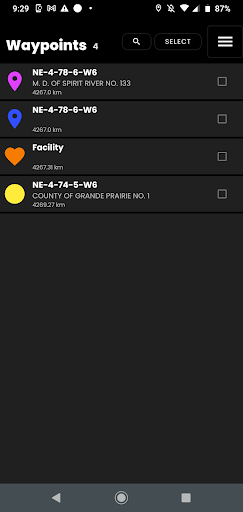
-Record waypoints: Include comments, choose from various symbols, and show/hide waypoint symbols on the map
-Record Trip Logs
-Manage waypoints and Tracks using the Waypoint and Tracks manager.
-Get directions to site using the Google Maps app.
-Get coordinates of your current position in multiple coordinates system formats.
-Get the Legal Description (Quarter Section) of your current position, by tapping on the blue "vehicle" icon
Paid Subscription Details:
-1 Year Subscription
-$9.99 per year
-Free 7-Day trial, cancel within 7 days without charge.
-Payment will be charged to Google Account at confirmation of purchase
-Subscription automatically renews unless auto-renew is turned off at least 24 hours before the end of the current period
-Account will be charged for renewal within 24 hours prior to the end of the current period, and identify the cost of the renewal.
Privacy Policy:
https://www.skybasews.ca/PrivacyPolicy/AgMap_PrivacyPolicy.html
Terms of Use:
https://www.skybasews.ca/PrivacyPolicy/AgMap_TOS.html
AgMap will find and route you to any Quarter Section legal description in Alberta, Saskatchewan, Manitoba and British Columbia (Peace River Block).
What else can AgMap do?
-AgMap will automatically draw the Quarter Section boundaries on the map as you drive down the road.
-Change between multiple Google Maps backgrounds include "Road Map", "Road Map Light", "Road Map Dark" and "Satellite".
-Save Quarter Section boundaries on the map, so you always know which quarter section you're in, even when the field spans many quarters.
-Record waypoints: Include comments, choose from various symbols, and show/hide waypoint symbols on the map
-Record Trip Logs
-Manage waypoints and Tracks using the Waypoint and Tracks manager.
-Get directions to site using the Google Maps app.
-Get coordinates of your current position in multiple coordinates system formats.
-Get the Legal Description (Quarter Section) of your current position, by tapping on the blue "vehicle" icon
Paid Subscription Details:
-1 Year Subscription
-$9.99 per year
-Free 7-Day trial, cancel within 7 days without charge.
-Payment will be charged to Google Account at confirmation of purchase
-Subscription automatically renews unless auto-renew is turned off at least 24 hours before the end of the current period
-Account will be charged for renewal within 24 hours prior to the end of the current period, and identify the cost of the renewal.
Privacy Policy:
https://www.skybasews.ca/PrivacyPolicy/AgMap_PrivacyPolicy.html
Terms of Use:
https://www.skybasews.ca/PrivacyPolicy/AgMap_TOS.html
Developer email
sales@skybase.ca
Developer website
https://www.skybase.caReleased
Jul 3, 2019
Current version
2.2.4
Android version
8.0
Screenshots